


Visimind uses Velodyne’s lidar sensors to provide lidar-based solutions for energy companies in vegetation management and more.
Increasing public safety in the energy sector with lidar
January 12th, 2023 by Jane Maynard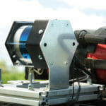
Elevating high-precision aerial lidar mapping with TOPODRONE and Velodyne Lidar
September 6th, 2022 by Jane Maynard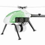
TOPODRONE’s newest product, the LiDAR PRIME + aOrion Heli-E, uses Velodyne’s lidar to provide their most advanced lidar system.
Researchers use Velodyne’s lidar to find tallest tree in China
July 7th, 2022 by Jane Maynard
Using both drone and backpack systems equipped with Velodyne’s lidar, researchers found and measured the largest tree in China.
Wissenschaftler finden mit Hilfe von Velodyne Lidar den höchsten Baum Chinas
July 7th, 2022 by Velodyne LidarUnter Verwendung von sowohl Drohnen- als auch Rucksacksystemen, die mit Velodynes Lidar ausgestattet waren, fanden und maßen die Forscher den größten Baum in China.
Des chercheurs utilisent le lidar de Velodyne pour trouver l’arbre le plus haut de Chine
July 7th, 2022 by Velodyne LidarEn utilisant à la fois des systèmes de drones et de sacs à dos équipés du lidar de Velodyne, les chercheurs ont trouvé et mesuré le plus grand arbre de Chine.
Automated with Velodyne: Netzwerk erreicht die 100er Marke
February 15th, 2022 by Velodyne Lidar
Das einzigartige globale Lidar-Ökosystemprogramm Automated with Velodyne hat die Marke von 100 Partnern erreicht.
Automatisé avec Velodyne : l’écosystème Lidar franchit le cap des 100 partenaires
February 15th, 2022 by Velodyne LidarLe programme mondial unique d’écosystème lidar Automated with Velodyne a atteint le cap des 100 partenaires.
Automated with Velodyne: Lidar Ecosystem Hits 100 Partner Milestone
February 15th, 2022 by Velodyne LidarAutomated with Velodyne (AwV) program has achieved the 100 partner landmark. AwV is a one-of-a-kind program in the lidar industry that spurs collaboration in commercializing next-generation autonomous solutions.
Exyn Delivers World-Class Autonomous Robots to Data-Hungry Industries
January 16th, 2022 by Velodyne Lidar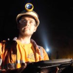
Jason Derenick, Chief Technology Officer at Exyn, discusses how they help companies and government with multi-platform autonomy.
Emesent Autonomously Mapping the Inaccessible
January 15th, 2022 by Velodyne Lidar
Dr. Jeremy Sofonia, Technical Evangelist at Emesent, joins Velodyne for a CES 2022 presentation on mapping GPS-denied environments.
Velodyne Lidar Executives Discuss Future of Lidar at Press Event
January 11th, 2022 by Melissa McFarlin
Velodyne Lidar executives spoke on how our lidar sensors and software are shaping autonomous solutions in a wide range of markets during a virtual CES 2022 press conference.
New Vella Development Kit Release Delivers Ability to Use Low-powered ARM-based Jetson AGX Xavier
December 17th, 2021 by Melissa McFarlin
Velodyne Lidar has delivered a new release of our Vella Development Kit (VDK) that simplifies building autonomous solutions.
La nouvelle version du kit de développement Vella permet d’utiliser les Jetson AGX Xavier à faible puissance basés sur l’architecture ARM.
December 17th, 2021 by Velodyne LidarVelodyne Lidar a publié une nouvelle version de notre kit de développement Vella (VDK) qui simplifie la création de solutions autonomes.
Neue Version des Vella-Entwicklungskits ermöglicht die Verwendung des ARM-basierten Jetson AGX Xavier mit niedriger Energieaufnahme
December 17th, 2021 by Velodyne LidarVelodyne Lidar hat eine neue Version unseres Vella Development Kit (VDK) bereitgestellt, das den Aufbau autonomer Lösungen vereinfacht.
Sinclair Vass Previews Velodyne’s Automotive Lidar Solutions at Auto Guangzhou 2021 (English)
November 12th, 2021 by Melissa McFarlin
Velodyne Lidar will demonstrate lidar solutions at Auto Guangzhou 2021 from Nov. 19 – 21 at the Canton Fair Complex in Guangzhou, China.
Safety, Sustainability and Efficiency Explored at the 2021 World Safety Summit on Autonomous Technology
November 9th, 2021 by Velodyne Lidar
he 2021 World Safety Summit on Autonomous Technology brought together leaders across industry, government, journalism, and academia to highlight autonomous technology and foster a greater understanding of its contributions to safety.
Aussie team of robot “Olympians” uses Velodyne’s lidar to score second place in the DARPA Subterranean Challenge Urban Circuit
October 5th, 2021 by Jane Maynard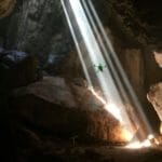
Team CSIRO Data 61 took home second place in the DARPA Subterranean Challenge Urban Circuit equipping their robots with Velodyne lidar.
Velodyne携手NavVis 和Qualcomm Technologies 共助智慧城市建设
May 10th, 2021 by Velodyne Lidar
Velodyne Lidar 和 NavVis 是 Qualcomm 智能城市加速器计划的成员,旨在开发智能城市应用。
South Korea: Innovation Center for Lidar-Based Autonomous Solutions
March 11th, 2021 by Jane Maynard
A look at Automated with Velodyne companies that have developed the innovative lidar-base autonomous solutions for mapping and robotics.
Automated with Velodyne Partners Leading the Way to New Autonomous Solutions in Korea
March 11th, 2021 by Jane Maynard
Members of the Automated with Velodyne integrator network are advancing new, cutting-edge autonomous solutions in Korea.
Velodyne, NavVis and Qualcomm Technologies Working Together to Build Smart Cities Faster
March 10th, 2021 by Velodyne LidarVelodyne Lidar and NavVis are members of the Qualcomm Smart Cities Accelerator Program to develop smart city applications.
Top 3 Takeaways From Velodyne Lidar and Emesent Webinar
February 23rd, 2021 by Albie Jarvis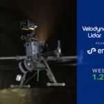
Overview of Velodyne Lidar and Emesent webinar discussing autonomous drone exploration and mapping in challenging settings.
Measure with Confidence with OxTS
January 5th, 2021 by Velodyne Lidar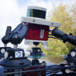
Learn how Velodyne’s lidar combined with OxTS Inertial Navigation Systems/GNSS technology can help systems location and orientation.
Top 3 Takeaways from the Velodyne – Kaarta Webinar
September 14th, 2020 by Albie Jarvis
Summary of Velodyne-Kaarta Webinar featuring Kaarta CEO Kevin Dowling discussing 3D reality capture with mobile scanning systems, using Velodyne’s lidar.
NavVis Enables Reality Capture in Complex Built Environments
August 25th, 2020 by Jane Maynard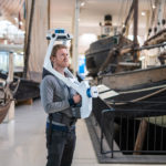
Georg Schroth discusses how NavVis mobile mapping systems use Velodyne lidar sensors to create digital twins of building environments.
Exyn Delivers Impossible to Reach Data with Breakthrough Autonomy
August 23rd, 2020 by Jane Maynard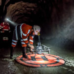
Interview with Exyn’s CTO Jason Derenick, discussing how their autonomous aerial robot systems, equipped with lidar, help mining, logistics & construction companies.
Top 3 Takeaways from the Velodyne – Gexcel Webinar
August 22nd, 2020 by Albie Jarvis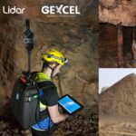
Velodyne and Gexcel discussed the role of 3D lidar in accurately tracking underground assets and stockpiles in mining.
MOBILTECH Powering Autonomous Solutions to Recognize the World as We Do
July 17th, 2020 by Jane Maynard
MOBILTECH offers 3D mapping scanners, which include Velodyne’s lidar sensors, that can be deployed in vehicle, handheld and UAV mode to create an HD map.
Mapping the Inaccessible with Lidar
June 8th, 2020 by Jane Maynard
Stefan Hrabar of Emesent discusses mapping with lidar using Hovermap, equipped with Velodyne’s Puck LITE™ lidar, in infrastructure, mining, & forestry.
Lidaretto 3D Scanning System Captures Accurate, Reliable Geospatial Data from Any Location
April 9th, 2020 by Albie Jarvis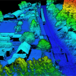
Geotech’s Lidaretto 3D mobile surveying system uses Velodyne Lidar Puck™ sensors to produce highly accurate point clouds for a variety field applications.
Velodyne LiDAR and LIDARUSA Unveil Mayan Ruins in 3D
November 5th, 2018 by Velodyne Lidar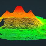
In the summer of 2014, a crew of National Geographic’s Discovery Channel program made an amazing discovery in the jungles…
Six Gifts Lidar Can Give to the World
December 14th, 2017 by Velodyne Lidar
Easier Commutes. In a recent round table on the 360 Blog, a pair of Velodyne visionaries share their hopes for self-driving cars…
GreenValley International: 3D Mapping for Improved Environmental Management
November 1st, 2017 by Velodyne Lidar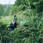
In Tanzania, a helicopter mounted with an advanced laser sensor hovers over a tropical forest. With the data gathered, modern…
GreenValley International LiBackPack Demo
May 31st, 2017 by Velodyne Lidar
GreenValley International recently visited Velodyne LiDAR’s Megafactory to demonstrate the breathtaking capabilities of their LiBackpack. Equipped with Velodyne’s VLP-16 LiDAR Puck, the LiBackPack…
A New Age of Exploration? Photogrammetry and LiDAR
January 18th, 2017 by Velodyne Lidar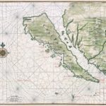
Beginning in the early 17th century, countless maps depicted California as an island floating just off shore from North America. As…
LiDAR for Search and Rescue
October 10th, 2016 by Velodyne Lidar
A rescue squad’s speed and efficiency can mean the difference between life and death for someone lost or trapped due…
LiDAR Mapping in Archeology
September 29th, 2016 by Velodyne Lidar
Archeologists uncover pre-historic mysteries so humans can understand the past. Traditional archeology requires hundreds of man-hours poring over old documents…


