


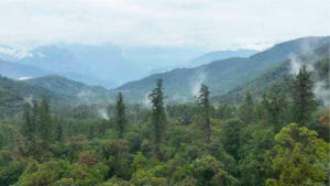
Using Velodyne Lidar’s Puck LITE sensor, a Peking University research team has discovered the tallest tree in China, now known as the “Tree King.” Using our lidar sensors on both a drone and mapping backpack, the team found and measured a Bhutan pine tree with a height of 76.8 meters (251.9 feet) in Green Village, Beibeng Township, Medog County, Tibet. According to China Daily, the team was performing “a large-scale surveying and mapping project using a drone-mounted lidar system” when the tree was found. While the tree was well-known among the local Moinba villagers and referred to as See Sky and Sindab (“sacred tree”), its precise height had always been a mystery.
During the university mapping project, researchers “found 11 giant trees potentially taller than 70 meters (229.7 feet). The team carried a backpack lidar into the forest hinterland to conduct detailed mapping of the 11 giant trees,” noted a ECNS.cn story. While doing this mapping work, they were able to determine that See Sky was in fact the tallest tree in China.
Li Cheng, the head of the Xizijiang Ecological Conservation Center, first discovered several particularly tall trees in the Green Basin after setting up an infrared camera for the Tibet Forestry Planning Institute. Based on his years of field investigation experience in Medog County, Li Cheng proposed that one of the trees, a Bhutan pine, may be the tallest tree in mainland China. In April 2022, commissioned by the Forestry and Grassland Bureau of Medog County, Peking University’s research group including Lv Zhi and Guo Qinghua, Xizijiang Ecological Conservation Center, Shanshui Nature Conservation Center, and GreenValley International conducted a joint investigation to study the Bhutan pines in Medog.
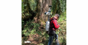
Previously, researchers used a drone to capture the height of the tree in the vast virgin forest, but were only able to make a rough estimate of the height. This time around, after considerable preliminary research and preparation, the research team entered the forest with a lidar-equipped unmanned aerial vehicle (UAV) and a lidar scanning system backpack. Using these together, the team was finally able to successfully find and accurately measure the identified tree. Professor Guo Qinghua of Peking University said, “Lidar is an active remote sensing technology that can directly, quickly and accurately obtain the 3D point cloud model of the research object.”
First, the research team used the UAV lidar system, equipped with a Puck LITE sensor, to conduct large-scale mapping of this primitive forest. Based on the lidar data, a 30-meter spatial resolution map of the forest’s canopy height distribution was drawn. The distribution map showed the average canopy height of the forest in Medog County was considerable, in fact the highest in all of China, and has the potential to grow even more giants.
After the UAV survey, the researchers carried the backpack lidar system, equipped with two Puck LITE sensors, into the forest hinterland. They conducted detailed mapping of the 11 giant trees that were thought to be higher than 70 meters and obtained 3D point cloud models of the 11 trees for accurate measurement.
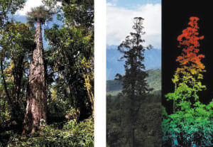
After 10 days of fieldwork, data collection and processing, the research team succeeded in measuring the exact height of the tallest Bhutanese pine in the forest at 76.8 meters (251.9 feet), setting a new record for the tallest tree in China. The research team also obtained 3D point cloud data of this tree and used drones to obtain hundreds of photos, stitching them together to form a photo of the tree. Height and diameter at breast height (DBH) were verified and detailed data was recorded. In the end, this outstanding Bhutan pine was deemed the Tree King of China and was finally able to be “seen” by the public.
“I am pleased and honored to hear the great news of our village having the tallest tree found on the Chinese mainland. I believe more people will pay attention to our hometown, and to the importance of ecological protection,” said Dorje Phuntsok, village leader of Jeling for China Daily.
To learn more about the sensor used in this project, visit our Puck LITE product page. To discover how Velodyne’s sensors are deployed in other mapping applications, check out our Mapping Industries page.
Contact Velodyne’s sales team at 669.275.2526 or [email protected] to discuss how our lidar hardware and software can advance your autonomous solution.
Watch this video from GreenValley to see the project in action!

Velodyne Lidar (Nasdaq: VLDR, VLDRW) ushered in a new era of autonomous technology with the invention of real-time surround view lidar sensors. Velodyne, a global leader in lidar, is known for its broad portfolio of breakthrough lidar technologies. Velodyne’s revolutionary sensor and software solutions provide flexibility, quality and performance to meet the needs of a wide range of industries, including robotics, industrial, intelligent infrastructure, autonomous vehicles and advanced driver assistance systems (ADAS). Through continuous innovation, Velodyne strives to transform lives and communities by advancing safer mobility for all.


