


Industries such as mining, logistics and construction are going digital to allow them to capture critical and time-sensitive data in a safer, more affordable and more efficient way.
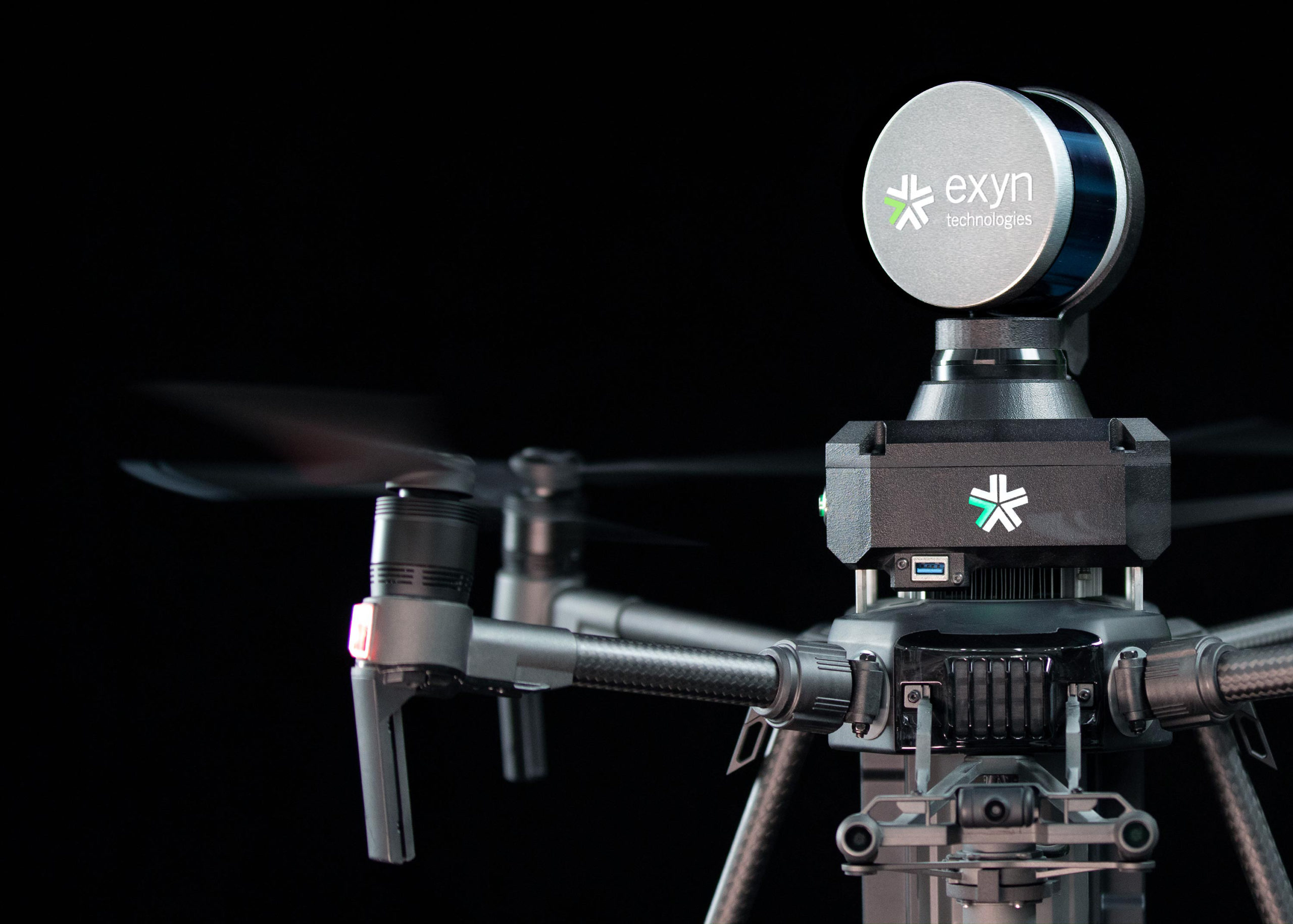
Exyn Technologies, an Automated with Velodyne partner, is pioneering autonomous aerial robot systems for GPS-denied environments. The company’s solution enables flexible deployment of single or multi robots that can intelligently navigate and dynamically adapt to complex environments in real time.
To learn more about Exyn and how its solutions help companies gather a larger and more accurate volume of data to improve business decisions and keep employees safe, we interviewed Jason Derenick, Chief Technology Officer at Exyn.
Jason: Exyn Technologies is a spin-off of the prestigious General Robotics, Automation, Sensing and Perception (GRASP) Laboratory at the University of Pennsylvania, and is commercializing decades of cutting edge research in the area of autonomous flight and aerial robotics. Our focus is in developing the foundational software components and core algorithms to enable self-contained (all computation and sensing done on board), safe and reliable autonomy in GPS-denied commercial environments. Exyn A3Rs have been successfully deployed in challenging real-world environments including deep mines and industrial warehouses.
Exyn’s team is comprised of some of the best talent in the world in the core areas of autonomy which includes control, perception, motion planning, state estimation, multi-sensor data fusion, and simultaneous localization and mapping. A majority of the team have earned doctoral degrees and/or completed post-doctoral research in a subset of these areas at leading institutions including Penn, Georgia Tech and Johns Hopkins. The team also has a tremendous breadth of industrial experience with members joining from Boeing Corporation, Sikorsky Aircraft Corporation, SRI and United Technologies Corporation.
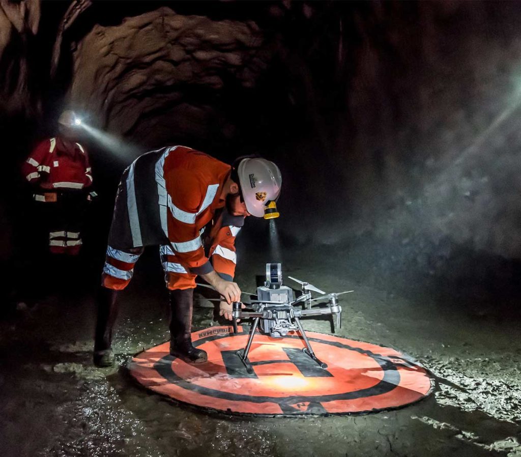
Jason: Mine surveying is a critical task necessary for designing and documenting information at all stages of mining. However current surveying techniques are struggling to keep pace with the industry. They’re labor-intensive, time-consuming and require specialized equipment. They also force surveyors to work extremely close to open stopes which can be one of the most dangerous places in a mine.
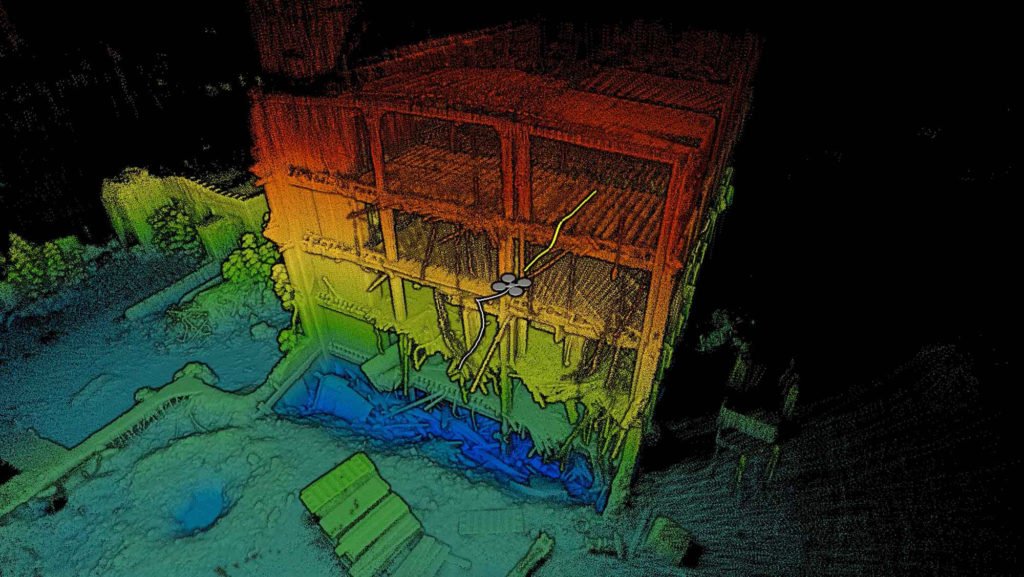
Our robots provide surveyors with a single system equipped to autonomously navigate and map a variety of underground cavities without the need for existing infrastructure. Once a surveyor sends a mission to the robot, the rest of the computation is handled entirely onboard. Meaning the robot can lose communication with the tablet or any existing infrastructure, and fly beyond line-of-sight, while still completing the mission and returning to a safe landing zone. Using Exyn A3Rs for autonomous data collection and mapping can vastly improve safety, save time and money, and enhance short interval control.
Jason: Semi-autonomous and tele-remote systems have been used in mine operations for almost two decades, mostly to keep miners away from dangerous machinery and spending less time underground. Current technology can allow trucks full of ore to be sent up the surface by themselves, or enable a loader to drive itself to an ore deposit and start collecting material while a miner controls the machine from the surface. This can prevent untold accidents and help streamline current mine operations.
However, these systems depend on reference maps and location markers to help them navigate underground. Remove that and they are essentially blind or reduced to a lower level of autonomy. The autonomy in our robots is entirely self-contained and can operate in dark, GPS-denied environments like the variety of cavities created in mining. Equipped with our robots, surveyors can map entire cavities in minutes with dense point clouds they can import into their existing software stack.
Jason: Velodyne has set the bar for 3D lidar sensor technology, and I have had the opportunity to extensively work with their sensors in the past for a variety of autonomous vehicle systems with great success. When it came to designing the A3R for industrial applications and selecting the primary lidar system, Velodyne was the obvious choice.
There are also several features that make the Puck LITE an extremely attractive option for autonomous aerial vehicles flying in dark, dirty and dangerous environments. In addition to its low-weight profile and relatively low power consumption, the system also provides calibrated reflectivity (useful for identifying “control points” in mines) and multiple returns per laser. The latter is extremely helpful when it comes to filtering out dust and particulates in the air that have been raised by the downwash of the system’s props.
Jason: The quintessential element is regular and rigorous testing of the system under a variety of conditions. These tests begin at the individual unit level where components are tested individually in isolation against prescribed preconditions and postconditions. Assuming those tests check out, we also perform system-level testing in a simulation environment to verify the interaction of the various system elements results in the proper system behavior without any regression. Finally, once simulations are carried out, we have several test locations that we leverage to run our systems through a deck of standard flight cards to ensure safe and repeatable performance. It is only when a system passes this gauntlet of tests that it is ready for actual fielding at customer locations.
Beyond testing, ExynAI is built from the ground-up using best practices and first principles in industrial-grade software development. This includes a pipeline for continuous integration that requires peer review and acceptance before a developer’s changes can be merged into the team’s primary development branch. We have a defined coding standard and make heavy use of developer profiling and performance tools. These include tools for identifying memory access violations, leaks and similar issues. We also code against the latest C/C++ standard to ensure we are able to take advantage of the latest language features to ensure safety.

Velodyne Lidar (Nasdaq: VLDR, VLDRW) ushered in a new era of autonomous technology with the invention of real-time surround view lidar sensors. Velodyne, a global leader in lidar, is known for its broad portfolio of breakthrough lidar technologies. Velodyne’s revolutionary sensor and software solutions provide flexibility, quality and performance to meet the needs of a wide range of industries, including robotics, industrial, intelligent infrastructure, autonomous vehicles and advanced driver assistance systems (ADAS). Through continuous innovation, Velodyne strives to transform lives and communities by advancing safer mobility for all.


