


Measuring production against plan is essential to understanding mining success. Without this information, it is impossible to gauge the progress made with any accuracy.
A webinar conducted by Dieter Gabriel, Marketing Manager EMEA at Velodyne Lidar, and Prof. Giorgio Vassena, Giorgia Rossi and Sara Treccani, all from Gexcel, discussed the role of 3D lidar in accurately tracking underground assets and stockpiles in mining.
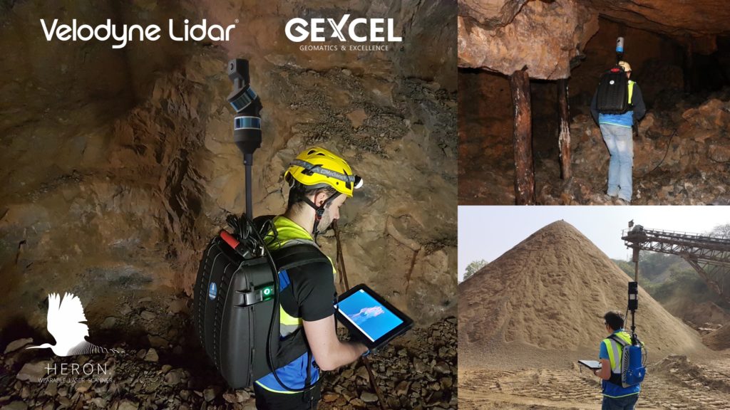
Gexcel started in 2007 with the mission to turn the latest scientific achievements in the field of geomatics into hi-tech products and services for wide application areas. Their HERON mobile mapping system, which is equipped with Velodyne’s lidar sensors, enables comprehensive, effective 3D surveying work. Users can wear it, walk and visualize in 3D their surroundings. HERON is able to adapt to a variety of application fields including mines and tunnels.
Here are three takeaways from the webinar:
Underground mines represent a difficult challenge for surveying activities. The dark, narrow spaces, sudden gradients, presence of water, dust and humidity, uneven paving and inability to receive a GPS/GNSS signal often make it impossible to apply the traditional survey techniques. Giorgia discussed how HERON as a compact, light and easy to transport system can overcome these challenges to survey the underground reality that surrounds you. She added surveyors have full control of the process through real-time 3D visualization of the acquired data.
Companies at mines and quarries need to regularly measure their stockpiles. Giorgia reviewed how HERON can rapidly map stockpiles for volume calculation and to get a fast check of volume changes. This helps companies create accurate measurements to define the volume of stock materials to guide management and enable quick decision making.
Cost is always a critical factor for surveyors. Giorgia noted that with HERON, there is no need to hire a big team or do multiple surveys for a project – because one person can produce a complete, accurate survey. The system allows a surveyor to cover up to 30 kilometers per hour – cutting field times for surveys, and because there is no need to close loops to complete a survey, productivity can be dramatically increased. And the Velodyne sensors in HERON can range of up to 100 meters which means surveyors are better able to stay away from hazards. Fewer people in the field, shorter time surveying and a long range system all can contribute to improved project safety.
These are just some of the numerous highpoints from the session. Watch the full webinar below!

Velodyne Lidar (Nasdaq: VLDR, VLDRW) ushered in a new era of autonomous technology with the invention of real-time surround view lidar sensors. Velodyne, a global leader in lidar, is known for its broad portfolio of breakthrough lidar technologies. Velodyne’s revolutionary sensor and software solutions provide flexibility, quality and performance to meet the needs of a wide range of industries, including robotics, industrial, intelligent infrastructure, autonomous vehicles and advanced driver assistance systems (ADAS). Through continuous innovation, Velodyne strives to transform lives and communities by advancing safer mobility for all.


