A recent study estimated that the global number of cars on the road will nearly double up to 2 billion by the year 2040. This increase will not only affect the level of traffic congestion but, more importantly, the number of accidents occurring on the road.
More than half of road traffic fatalities occur among the most vulnerable road users, pedestrians, cyclists and motorcyclists, and the cost of injuries sustained in accidents are a major burden on our healthcare systems. It’s been shown that car crashes cost countries 2%-8% of their gross domestic product.
Many cities have been using inductive loops for traffic management, but the technology is expensive to install and maintain. What’s more, traffic loop systems aren’t able to provide the kind of detailed data that is needed to understand what is going on at an intersection and make meaningful improvements.
The reality is that road crashes can be prevented with better traffic data. Up until recently, the methods used to obtain the data cities need to improve road safety were inductive loops, radar and video cameras, however each had drawbacks, including cost, data limitations, privacy issues and more. Utilizing new technology like lidar and AI can addresses those limitations for improved data collection and more meaningful and effective traffic management.
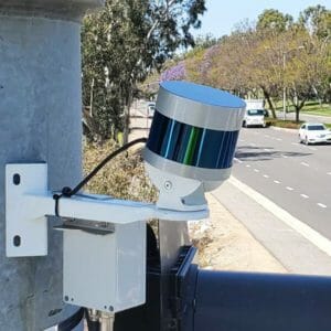
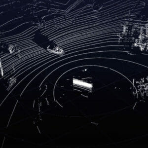
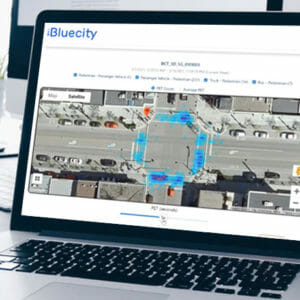
This is why BlueCity combines lidar sensors and artificial intelligence to capture traffic data on all road users. Installed at the intersection, the lidar sensor capture data, and a perception software layer identifies the different road users. BlueCity provides cities with count data, speed analytics and the most advanced safety analytics.