


Interview with Brad Ysseldyk, Global Autonomous Business Development Manager of Applanix, a Trimble Company
Applanix, a wholly-owned subsidiary of Trimble, is a Velodyne partner and using lidar for a slew of innovative projects. I invited Brad Ysseldyk to share some thoughts with us on how Applanix is delivering on their vision for furthering industrial automation, and what industries and use cases they see moving most quickly towards automation.
Applanix develops and manufactures products for mobile mapping surveying and driverless vehicles. Applanix systems, software and solutions are designed for pinpoint positioning.
Positioning and mapping are at the heart of automation. The algorithms and method for achieving autonomous navigation in an unknown environment is often referred to as simultaneous localization and mapping (SLAM). This is where Applanix comes in. They focus on developing the SLAM algorithms and components needed for a system to achieve full autonomy.
Applanix’s Autonomy Development Platform provides SLAM capabilities in a customizable environment to support any stage of development. From idea to full production, the platform can help bring driverless cars, self-navigating robots and other autonomous systems to fruition.
So, with that in mind, let’s get into it with Brad.
A. Among the biggest challenges we are addressing are the unique needs and specifications of clients. We find operating environments of our clients vary widely and are frequently changing. During normal operation, the typical GNSS + Inertial solution will output position, acceleration and velocity data which can be used for relative positioning of the vehicle.
However, the challenge arises in areas of poor GNSS coverage or when the vehicle traverses an area where RTK GNSS is unavailable and the position estimate error grows. How the vehicle accurately maintains its relative and absolute positioning from a failsafe perspective is critical.
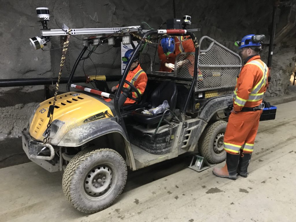
Use cases range from mining and seaports to industrial installations, such as steel mills. Anywhere prolonged GNSS outage may occur and ultimately affect AV positioning and localization, regardless of vehicle type, is what Applanix is addressing. During these outages, we still have access to IMU data which provides velocity and incremental distance travelled. This will allow us to maintain two independent sources of measurement and provide continuity between the GNSS/IMU and localization systems, maintaining fail safe positioning. The localization system will be following an absolute basemap while the POS LV will reconverge when RTK GNSS is available.
A. Along with flexibility, the robustness of the solution is what stands out to customers. A drawback to GNSS systems is they require line of sight to the sky. The Applanix Autonomy Development platform with lidar localization is a robust solution that operates independent of GNSS. Being an active sensor, it is unaffected by changes to ambient light. Furthermore, it is robust to changes in scenery, such as pedestrians or moving vehicles.
Flexibility of the Autonomous Development Platform is manifest as an easily integrated turnkey system that can be deployed in volume for any application. These applications include real-time positioning and orientation for autonomous vehicles, dedicated mapping vehicles, logging data for crowdsourced maps and advanced driving assistance systems (ADAS) testing.
We regularly assist OEMs with modifications in their autonomous projects, which can be configured and changed during their test programs. When testing and validation are completed, we can easily scale components to meet the price and performance for large quantity orders.
A. Our clients provide us with interesting positioning challenges which have allowed us to deploy our localization and GNSS-inertial solutions with great success across a broad array of applications.
Rail applications is a great example of an area where precise positioning is an absolute necessity. We are working with manufacturers and operators which are using our platform to ensure absolute positioning and localization during extended outage or non-existent GNSS conditions. Long haul trucking is another area of significant growth where we are spending a lot of time with manufacturers and integrators developing precise localization solutions for similar environments.
Although this list is not exhaustive, it highlights where we are spending time and some of the AV applications that are embracing our approach.
A. Having GNSS-inertial along with lidar-based localization (SLAM) allow our clients to have confidence in the integrity of the measurements and a seamless transition between GNSS environments. Regardless of where the vehicle is operating, as it moves in and out of various GNSS conditions, Applanix will maintain the accuracy and performance of the position and localization solution. There are many companies working on providing reliable means of positioning for AVs. We hear the term “sensor fusion” used to describe combining individual data streams from various sensors to perform localization and perception tasks. The only way this can truly be achieved and deployed comprehensively is to have Velodyne’s lidar as a part of our kit, which works effectively in a range of light and environmental conditions.
A. Velodyne’s pedigree is such that the company has established itself as a leader in the AV space. Based on Velodyne’s history, its current position as segment leader and the company’s proven dedication to future development, we chose to launch our platform with Velodyne Lidar sensors. We feel that the exceptional sensor quality is a perfect fit for our dedication to customer satisfaction and high-quality performance.
A. We are always striving to build on and improve our core technologies. As it pertains to automated vehicles (AVs), our focus is on working with all of our partners to provide customized products, which requires us to go beyond the GNSS-inertial solution to meet their operating conditions. For example, we will incorporate other Trimble products as just one way to enhance our own offerings.
This does not simply pertain to hardware developments, as other added value processes can be built upon. We perform critical, detailed steps before deploying our localization solutions including characterizing sensor performance, ensuring that the sensor will work with our localization software, and validating items such as precise timing and calibration. We look forward to continuing to grow along with our customers!

Velodyne Lidar (Nasdaq: VLDR, VLDRW) ushered in a new era of autonomous technology with the invention of real-time surround view lidar sensors. Velodyne, a global leader in lidar, is known for its broad portfolio of breakthrough lidar technologies. Velodyne’s revolutionary sensor and software solutions provide flexibility, quality and performance to meet the needs of a wide range of industries, including robotics, industrial, intelligent infrastructure, autonomous vehicles and advanced driver assistance systems (ADAS). Through continuous innovation, Velodyne strives to transform lives and communities by advancing safer mobility for all.


