Longer commute times, long lines of cars waiting at intersections and slower speeds: all are symptoms of the traffic congestion problem. In some busy urban areas, drivers can spend up to 119 hours a year stuck in traffic. With over 80% of commuters choosing private vehicles to get to work and traveling at the same time, many road systems struggle to handle peak-hour loads. All those idling cars also lead to increased carbon emissions. Solutions include improving traffic flow with better timing of traffic lights, improving infrastructure planning by considering pedestrians and cyclists and reducing car crashes that block arteries. Transport planners have their hands full trying to find methods to address the traffic congestion problem.
Current methods are unable to provide multimodal data on vulnerable road users or data in real time. Safety analytics and information about vehicle speed, crashes, trajectories or turning directions are difficult or impossible to obtain. Even when the available information is used, once adjustments are made to intersections, new studies must be implemented to measure the results of the changes to see if they are successful.
Inductive loops, radar and video cameras have been used to obtain the data cities use to make policy changes regarding intersections, but each comes with its own set of drawbacks, including high costs and data limitations. In the case of video cameras, privacy has also become an issue for citizens’ rights groups.
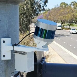
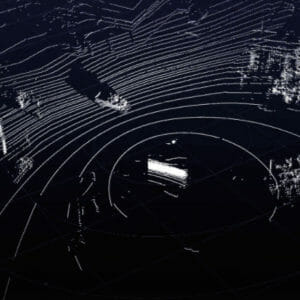
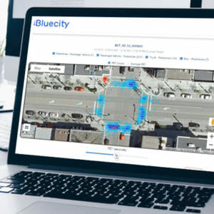
Traffic flow at intersections can be dramatically improved thanks to solutions that provide traffic controllers with accurate, real-time information on all road users, including pedestrians and cyclists. The BlueCity solution, which combines lidar with AI perception software, can be installed at any intersection to detect road users and communicate the information to traffic controllers. This data can be used to adjust the timing of traffic lights and extend the amount of time allotted to pedestrians to cross the street.
This is why BlueCity combines lidar sensors and artificial intelligence to provide real-time multimodal data for city engineers, transport planners and consulting firms involved in improving traffic flow. Fully GDPR-compliant and reliable in all weather and lighting conditions, cities all over the world can count on BlueCity to capture the traffic data needed to optimize traffic lights and reduce congestion.