


Our Velodyne Lidar LIVE! series featured part two of a discussion with Asad Lesani, Co-founder and CEO at Bluecity, on our Intelligent Infrastructure Solution (IIS). The episode focused on how IIS can advance data-driven infrastructure and urban planning.
IIS is a full-stack hardware plus software solution designed to help governments solve some of their most challenging and pervasive infrastructure problems. It combines our lidar sensors and AI software from Bluecity to monitor traffic networks. The system generates real-time data analytics and predictions, which help to improve traffic flow efficiency, advance sustainability and protect vulnerable road users.
During the session, Asad discussed how IIS is being used for Vision Zero activities and future mobility.
Here are three takeaways from the webinar:
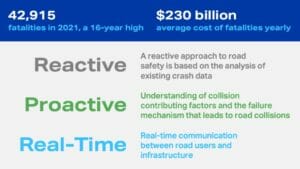
The traditional way cities improve road safety is to look at crash data to identify causes and issues related to crashes. That’s a reactive, lengthy approach. IIS enables a proactive approach where cities don’t need to wait for an accident to happen to identify traffic safety issues.
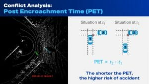
IIS enables city planners to measure post encroachment time (PET), which is the time difference between one vehicle leaving the area of encroachment and conflicting vehicle entering the same area. The shorter the PET, the higher risk of accident will be at an intersection. IIS can measure PET 24/7 for different types of road users, different types of turning movement and at different times of day. This can help city planners see points of conflict in intersections that need to be addressed.
We are headed to a collaborative environment between infrastructure and road users. IIS supports Vehicle to Infrastructure (V2X) communication that provides connected vehicles and autonomous vehicles with reliable multimodal traffic data. The solution converts that data into insights which vehicles can use in daily activities.
Intelligent Infrastructure Solution provides cities the opportunity to advance Vision Zero strategies and help make their streets safer for pedestrians, cyclists and motorists.
For more information on Intelligent Infrastructure Solution, contact Velodyne Sales: 669.275.2526, [email protected].

Velodyne Lidar (Nasdaq: VLDR, VLDRW) ushered in a new era of autonomous technology with the invention of real-time surround view lidar sensors. Velodyne, a global leader in lidar, is known for its broad portfolio of breakthrough lidar technologies. Velodyne’s revolutionary sensor and software solutions provide flexibility, quality and performance to meet the needs of a wide range of industries, including robotics, industrial, intelligent infrastructure, autonomous vehicles and advanced driver assistance systems (ADAS). Through continuous innovation, Velodyne strives to transform lives and communities by advancing safer mobility for all.


