


The University of Nevada, Reno’s Nevada Center for Applied Research has conducted research to find ways to make transportation infrastructure more efficient, sustainable and safe. They used Velodyne’s Ultra Puck™ lidar sensors to collect data to improve traffic analytics, increase pedestrian safety, reduce accidents and work toward facilitated use of autonomous vehicles.
A white paper, called “Roadside Lidar Helping to Build Smart and Safe Transportation Infrastructure,” (download here) summarizes the project’s research data and results.
The societal and economic harm from motor vehicle crashes amounted to $871 billion in a single year in the United States according to a study released by the U.S. Department of Transportation’s National Highway Traffic Safety Administration (NHTSA). The human toll is also heavy with a 2017 NHTSA study showing more than 37,000 people died in the U.S. in motor vehicle crashes. NHTSA research also shows, on average, a pedestrian is killed every 88 minutes in traffic crashes in the United States.
Existing roadway traffic data, such as flow rates, occupancy, average speed and spot speed, have been widely used to improve traffic mobility and safety. Yet new traffic systems and applications require traffic flow information with more detail and higher accuracy – specifically, multimodal, all-traffic trajectories. Ways this information can be used include monitoring and predicting vehicle-pedestrian conflicts on roads, evaluating traffic performance, analyzing near-crash events, providing data to connected and autonomous vehicles and more.
Existing traffic sensors, including radar and camera, do not provide trajectory or 3D data. And camera performance struggles in dark environment. By comparison, lidar sensors with 360-degree surround view capabilities are an attractive option because they capture 3D data of surrounding objects with high accuracy and frequency. Lidar sensors also can function in a range of lighting conditions, including daytime, dusk and nighttime.
As part of their research, the University of Nevada, Reno project team developed algorithms specifically for roadside lidar sensing systems. The group continued with proof-of-concept research to evaluate the accuracy, reliability and efficiency of the developed algorithms and roadside lidar sensing systems for various traffic scenarios and applications.
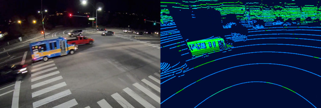
The project validated the feasibility of using roadside lidar sensors to provide high-accuracy, multimodal traffic trajectories by testing with different sensors, deployment methods and traffic scenarios. It demonstrated roadside lidar data can support connected-and-autonomous vehicles (CAV), enhance traffic mobility and safety analysis, and integrate with traffic infrastructure for automatic pedestrian/wildlife warning.
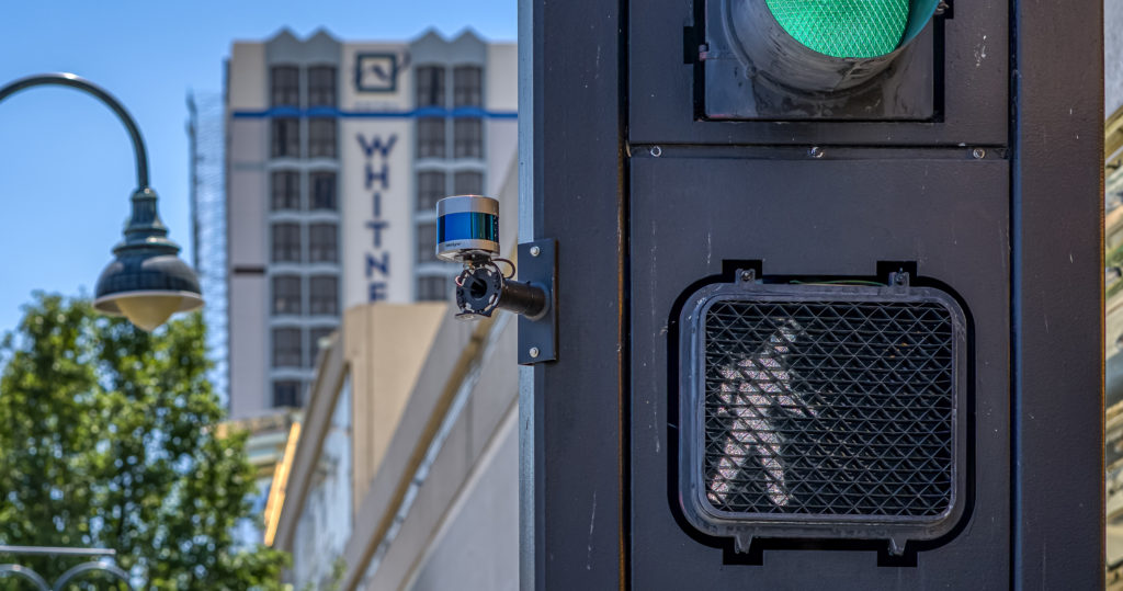
The project achieved successful implementation of lidar-based automatic rectangular rapid flash beacons (RRFB). Unlike conventional RRFB, these lidar-based systems not only serve the crosswalk area but provide many additional functions. These include traffic performance data collection, jaywalk event recording and supporting infrastructure to serve CAVs and connected non-motorist roadway users.
The research shows that lidar is a foundational technology that can help drive intelligent mobility in smart city applications and in vehicles on our roadways. It can help improve pedestrian crossings on streets and enable better protection for children in school zones. Lidar can be a catalyst for smart city applications that improve public services and enhance safety and quality of life.
The research detailed in the white paper was conducted by the University of Nevada, Reno’s Nevada Center for Applied Research, in conjunction with the Regional Transportation Commission of Washoe County, Regional Transportation Commission of Southern Nevada and the Nevada Department of Transportation.
The project deployed Velodyne’s Ultra Puck lidar sensors with traffic signals in real-world test environments, known as Living Laboratories, in Reno and Henderson. It was sponsored by the Nevada Governor’s Office of Economic Development.

Velodyne Lidar (Nasdaq: VLDR, VLDRW) ushered in a new era of autonomous technology with the invention of real-time surround view lidar sensors. Velodyne, a global leader in lidar, is known for its broad portfolio of breakthrough lidar technologies. Velodyne’s revolutionary sensor and software solutions provide flexibility, quality and performance to meet the needs of a wide range of industries, including robotics, industrial, intelligent infrastructure, autonomous vehicles and advanced driver assistance systems (ADAS). Through continuous innovation, Velodyne strives to transform lives and communities by advancing safer mobility for all.


