


Stroads are a hybrid of streets and roads. Streets provide access to communities, where people interact with businesses and residences, while roads provide high-speed mobility between two places. Stroads are a hybrid of the two, attempting to provide both access and mobility. Transportation and public works departments have been building stroads for decades, yet the goal of stroads has fallen short and they tend to be dangerous, complicated and inefficient.
According to Charles L. Marohn, Jr. in Confessions of a Recovering Engineer, “Stroads are the futon of the transportation system. A futon is an uncomfortable couch that converts into an uncomfortable bed, something that performs two functions but does neither well.”

So, have you ever driven on a stroad? Visualize yourself in the city where you live or work. As you are driving in your lane, is your speed alternating between 30 and 55 miles per hour? Are there wide lanes, turning lanes, recovery areas and other applications that support higher speeds of travel? Chances are you’re driving on a stroad.
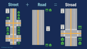
Stroads are expensive and they can stifle community prosperity and growth. With a large investment in steel, asphalt and land, one might think we could travel efficiently and safely along a stroad, but it’s quite the opposite. Stroads are designed for speeds between 30 and 55 miles per hour, with frequent stops at traffic lights to facilitate community access. As a result, stroads create dangerous conditions and congestion that plague our communities and pose risk to vulnerable road users.
These negative effects are preventable. In order to address them, cities need to be proactive and not reactive in their planning and decision-making. But to be proactive cities need the right tools. We live in an era where information is delivered instantaneously. For example, we can open the Amazon app on our phones and receive next-day delivery for just about anything. Shouldn’t it be the case that our civic leaders have the same kind of access to accurate, real-time data about streets and roads? This access to data is more important than ever as roads become ever more dangerous. With the passage of the $1.2 trillion infrastructure law in the US, local and state governments will now have the opportunity to be proactive and convert stroads into streets or roads, which will improve efficiency and safety for all road users.
It is imperative that a government organization looking to modernize its community’s infrastructure understands which technologies and datasets solve which problems. Some cities are leveraging powerful Intelligent Transportation Systems (ITS). Technologies like lidar and artificial intelligence (AI) are being used together for the first time in city environments for these intelligent transportation systems, informing decision-making and strategy.
Lidar is game-changing technology in these intelligent infrastructure solutions. Unlike older technologies, such as camera, radar and inductive loops, lidar creates a real-time, 3D map of roads and intersections, delivering precise traffic monitoring and analytics.
Lidar reliably collects data in a wide range of lighting or weather conditions, supporting 24/7, 365-days-a-year operation. Additionally, as privacy concerns grow, there is a need for non-biased technology. Lidar sensors do not identify biometric data, such as facial features and skin color. This helps preserve community trust as well as compliance with privacy laws.
So where do we start? The following three steps can be used by local and state governments to assess lidar for their infrastructure modernization needs.
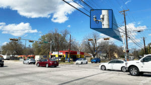
Small initial steps can lead to big leaps in safety. For instance, the city of Austin, Texas is deploying Velodyne’s Intelligent Infrastructure Solution (IIS) to help achieve its Vision Zero goal of eliminating traffic deaths and serious injuries on Austin streets. The IIS installation began with a pilot at the 7th and Springdale intersection. This intersection has been identified as needing improvement due to accident history, fatality risks, speeding prevalence and congestion. The City of Austin is testing IIS at this intersection to demonstrate data accuracy and scalability to maximize taxpayers’ dollars.
Companies, local governments and universities are partnering to improve traffic efficiency and road safety. For example, Velodyne is collaborating with the Rutgers Center for Advanced Infrastructure and Transportation (CAIT) to deploy our Intelligent Infrastructure Solution. CAIT has installed Velodyne’s lidar sensors at multiple intersections in New Brunswick, New Jersey. The project serves as a testbed for mobility data-gathering, analysis and sharing technologies that will help implement connected and autonomous vehicle systems in the future.
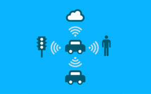
The future of transportation includes infrastructure interacting with vehicles through wireless technologies. For example, ITS applications can use lidar to extract trajectory road user data around intersections to predict potential collisions. This data can be used to warn connected vehicles through Vehicle to Everything (V2X) communications. Vehicle manufacturers can leverage ITS analytics in combination with their on-board safety systems to reduce collision probability.
The combination of funding availability for infrastructure projects and emerging smart technologies across the mobility ecosystem means we can now finally bring order to the chaos of stroads. Intelligent infrastructure can be utilized to help with the conversion of stroads to either streets or roads. This will improve sustainability and efficiency as well as protect vulnerable road users such as pedestrians.
If you are interested in leveraging lidar for your infrastructure program, contact Austin Wilson, Director of Intelligent Infrastructure, at [email protected] or make an appointment here.
Learn more about Velodyne’s Intelligent Infrastructure Solution here.

Velodyne Lidar (Nasdaq: VLDR, VLDRW) ushered in a new era of autonomous technology with the invention of real-time surround view lidar sensors. Velodyne, a global leader in lidar, is known for its broad portfolio of breakthrough lidar technologies. Velodyne’s revolutionary sensor and software solutions provide flexibility, quality and performance to meet the needs of a wide range of industries, including robotics, industrial, intelligent infrastructure, autonomous vehicles and advanced driver assistance systems (ADAS). Through continuous innovation, Velodyne strives to transform lives and communities by advancing safer mobility for all.


